Onboarding
Download the Whale Report app and create an account by entering your name and email address.
If you have previously submitted sightings to Ocean Wise, you have an account with us. Click "reset password" and enter your previously used email address, this will allow you to log in and view all sightings you've submitted.
Click “Next” to save your details (details are not shared outside of Ocean Wise).
Continue setting up your account or click “Skip” to bypass steps.
Setting Your Experience
Select the option that best describes your reason for being on or near the ocean.
Click “Next”.
Setting Your Seasons
This helps adjust observer effort for seasonal animal presence modeling.
Select all seasons when you are often on or near the ocean.
Click “Next”.
Turning on Location Services
Click “Next” and select “Allow while using app” on mobile.
On desktop, ensure location services are turned on.
Enabling Notifications
Click “Next” and then “Allow” on the pop-up (mobile users).
On desktop, enable notifications in your browser settings if not prompted.
What If You Are Out of Reach?
Sightings are saved offline and uploaded once you regain connection.
Click “Next” to complete account setup.
Creating a Report
To submit a sighting report, click on the “Map” page and click “Report A Sighting” to initiate your submission.
Pin the Approximate Location:
Select a point on the map (ensure it's in the water).
Click "Next".
Direction of Travel:
Choose a direction arrow or "I'm Not Sure".
Date and Time:
Enter the sighting date and time using the date/time bar provided.
Click “Next”.
Species:
Select the species or “I’m Not Sure”.
Click “Next”.
If you select Killer Whale, you may additionally select the ecotype.
Set Your Confidence Level:
Use the scale to indicate the certainty of the species you selected.
Click “Next”.
If you select “I’m Not Sure” indicate how certain you are that you saw a cetacean or sea turtle.
Animal Count:
Enter the exact or appropriate number of animals.
Click "Next".
Sighting Platform:
Select how you observed the animal(s).
Provide additional details if they are known (e.g., vessel name, location description).
Click “Next”.
Report Overview:
Review and edit details using the edit pen icon in the corner of each box.
Add behavior notes, comments, or photos.
Click “Submit”.
General Use of Whale Report
Map
Use this page to view an interactive map of recent whale sightings (24-hour delay for public sightings, real-time for your own sightings).
Map Interactions:
Use two fingers to zoom (mobile) or +/- buttons (desktop).
Click on points to see sighting information and select “View” to see more specific details.
Filtering:
Adjust the date by clicking on the date range box.
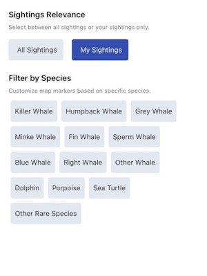
Click on the filter icon box to filter your map by relevance (your sightings or all sightings).
Filter by species if you wish to only view sightings of specific species types.
Marine Mammal Regulations and Guidelines:
At the bottom of the filter box, toggle Marine Mammal Regulations (MMRs) on/off.
Click on any MMR zones on your map to learn more about each regulated area.
Changing View:
Switch between list view and map view using the corresponding icons.
View the map legend by clicking the blue “i” icon.
On mobile, click the four-corner icon for a clear display.
On mobile, Re-center your location by clicking the target icon.

Sightings
View total sightings and alerts sent.
Use this page to also review your submitted recent sightings.
Profile Settings
Click your profile image (top-right) to:
Edit personal information.
Adjust notification preferences.
Change password.
My Alerts
Learn about what Whale Report Alert System (WRAS) is.
Who is eligible to apply: commercial mariners, commercial and government vessels, research and conservation organizations. WRAS is not for personal use or ecotourism activities.
Why WRAS is essential for protecting at-risk marine cetaceans and turtles.
Interested in WRAS? Read the How to Apply for WRAS Access guide.
Resources
Species Guide: View species specific information.
Report Dead and Distressed Animals: Information on regional contacts for reporting a dead or distressed animal.
Threats: Learn about threats like contaminants and vessel disturbance.
FAQ: Read frequently asked questions.
Actions: Discover how to support whale conservation (e.g., adopting a whale).
Downloads: Access PDFs like species identification and entanglement guides.
Reviewing Your Recent Sightings
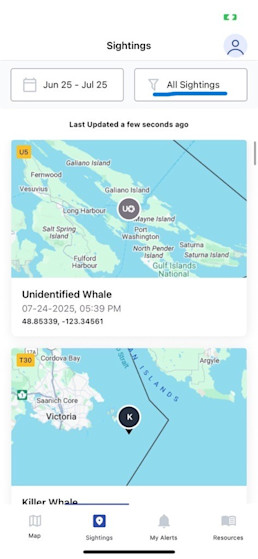
At the end of your day, week or month, if you wish to review all of your submitted sightings, select the Sightings page.
Click on the filter box, on the top of the page.

In the filters, select My Sightings.
Filter for any species, if you would like to only see certain species you have submitted sightings for.

Exit the filter box and select the date range you would like to view your sightings for.
Still have questions? Contact us Here.